Waipiʻo is the valley on the postcards: a mile-wide green floor between cliffs that rise straight out of the sea, a river winding to a dark sand beach, and waterfalls in the back of the valley. It sits at the end of the road on the Hāmākua Coast, on the island’s northeast corner, and for generations it was the home of Hawaiʻi Island’s ruling chiefs.
It is also a place where people live and farm, and access has changed in the last few years. Here is what you can do now, how to get there, and how to visit well.
Can you go into Waipiʻo Valley right now?
Not on your own. The steep road from the lookout down to the valley floor has been closed to independent visitors under a Hawaiʻi County emergency rule, which the county has renewed through at least November 1, 2026. Apart from residents, access is limited to guided or permitted visits. That means no driving down, and no walking down the road either.
The rule is renewed periodically and could be changed, extended or lifted, so check Hawaiʻi County’s current status for the Waipiʻo Valley access road before you go. Do not rely on an old blog post, a map app, or a rental-car guidebook, and do not try to talk your way past the gate.
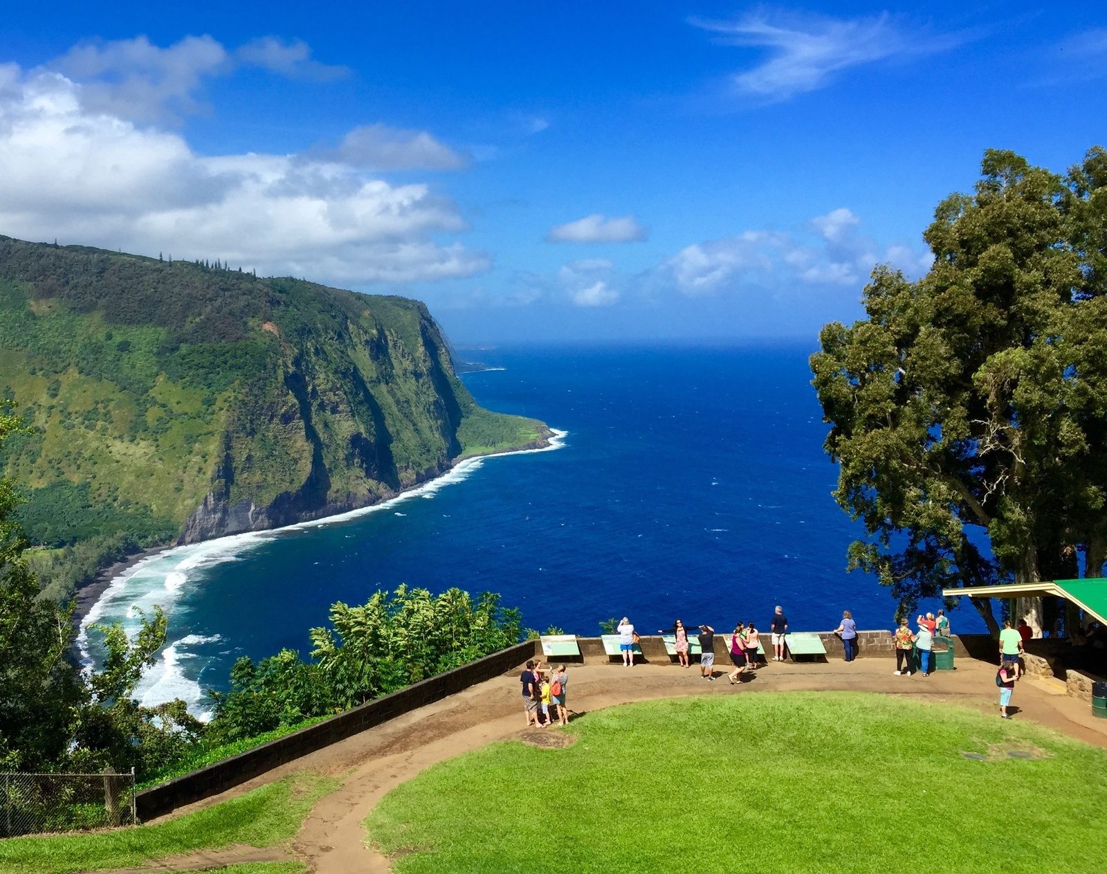
The good news is that the view most visitors come for has never needed the road. The Waipiʻo Valley Lookout is open, and it is how almost everyone sees the valley.
The Waipiʻo Valley Lookout
Highway 240 ends at the lookout, a small park on the cliff edge past the village of Kukuihaele. From the stone wall you look down the length of the coast: the valley floor, the river meeting the ocean, the dark sand beach, the surf, and the sheer cliffs on the far side running off toward the next valleys you cannot see from here.
A few practical notes:
- Go early. Morning usually has the clearest air and the softest light, and parking is limited.
- Plan 20 to 30 minutes. That is enough to take it in, take photos and read the signs.
- Stay behind the wall. The cliff edge is unstable and the drop is serious.
- Bring a rain jacket. This is the wet side of the island, and showers roll through without warning, then clear just as fast.
How to get there
From the Kona side, drive north and cross through Waimea, then follow Highway 19 down the Hāmākua Coast to Honokaʻa and turn onto Highway 240. Plan about 1 hour 45 minutes from Kona. From Hilo, it is about an hour north on Highway 19 along the coast.
Highway 240 runs along the cliffs from Honokaʻa, through Kukuihaele, and ends at the lookout. There is no way to continue past it by car. If you are staying in Kona and don’t want to spend three and a half hours in the car, the Waipiʻo Valley waterfall tour picks up at Kona and Waikoloa hotels.
Our Big Island areas map shows the Hāmākua Coast in relation to Kona, Waimea and Hilo, and our Kona vs Hilo guide has the drive times side by side.
Honokaʻa and Kukuihaele
Honokaʻa is the old plantation town on the bluff above the coast, one of the communities built around the Hāmākua sugar industry. The main street still has its wooden storefronts, with cafés, bakeries, antique shops and a historic theater. It is the natural place to stop for lunch, fuel and a restroom on the way to or from the lookout.
Kukuihaele is the last village before the lookout, a handful of homes and small businesses on the rim. Drive slowly through it; people live here, kids walk this road, and the road is narrow.
Waterfalls on the Hāmākua Coast
The Hāmākua Coast between Waipiʻo and Hilo is cut by gulches and streams, and on a wet week it is waterfalls the whole way. These are the ones we send people to.
ʻAkaka Falls
In ʻAkaka Falls State Park above Honomū, about 20 minutes from Hilo, a short paved loop through the rainforest leads to a view of ʻAkaka, a 442-foot waterfall falling into a gorge, with Kahuna Falls along the way. There are stairs, and visitors pay a small entry and parking fee. Allow 30 to 45 minutes.
The private falls near Honomū
The best waterfalls on this coast are on private land, which means you need a guide. The Hilo waterfall hike is a 2.5-hour guided walk from Honomū to falls you cannot reach on your own, from $140, ages 4 and up.
Rainbow Falls
In Hilo itself, Rainbow Falls (Waiānuenue) on the Wailuku River is a short walk from the parking lot and free. Come in the morning with the sun behind you for the rainbow.
The sea cliff waterfalls
Some of the most striking falls on this coast pour straight off the cliffs into the ocean, and you only see them properly from the water. The Hilo waterfall cruise runs along the Onomea cliffs north of Hilo for 1.5 to 2 hours, from $159.
Laupāhoehoe Point
Not a waterfall, but worth the turn off Highway 19 about halfway between Hilo and Honokaʻa: a low lava point with surf crashing on black rock, and a memorial to the people, including schoolchildren, lost here in the 1946 tsunami. The ocean here is not for swimming.
Why Waipiʻo matters
Waipiʻo means curved or arching water, after the river that bends across the valley floor. It is often called the Valley of the Kings, because for generations it was the seat of Hawaiʻi Island’s ruling chiefs. The chief Līloa ruled from here, and the valley held heiau (temples) and a puʻuhonua, a place of refuge, along with the homes of a large farming population.
What fed them was kalo, or taro. The valley’s water and soil made it one of the great taro-growing places in the islands, and families still farm loʻi kalo (wetland taro patches) on the valley floor today. The tsunami of 1946 swept through the lower valley, and many families left afterward, but Waipiʻo has never been empty.
That is why respect matters here. The valley floor is mostly private land, and the people who live there depend on that one steep road. When you visit:
- Stay on public land. The lookout is public; the valley floor mostly is not.
- Don’t fly drones over the valley or people’s homes.
- Don’t take rocks, sand or plants from the area.
- Follow the current access rules even if you see someone else ignoring them.
Seeing Waipiʻo with a guide
If you are based in Kona or Waikoloa, the easiest way to see Waipiʻo and the waterfalls in one day is the Waipiʻo Valley lookout and private waterfall swim. It is a 10-hour guided day with pickup at major Kona and Waikoloa hotels, the Waipiʻo Valley Lookout, a swim in a waterfall on private land, and a tropical garden. From $249, ages 5 to 89.
To be clear: this tour sees Waipiʻo from the lookout. It does not take you down into the valley. What it adds is the driving, the stories along the Hāmākua Coast, and a waterfall swim you could not get to on your own.
If you are staying in Hilo, drive to the lookout yourself in about an hour, and spend the rest of the day on the waterfalls above. For more on fitting this coast into a week, see our 7-day Big Island itinerary, and for the rest of the island, our things to do on the Big Island guide. The Hāmākua Coast is at its greenest in the wetter months; our guide to the best time to visit the Big Island covers the seasons.
FAQ
Is Waipiʻo Valley open to visitors?
The Waipiʻo Valley Lookout is open. The road down into the valley has been closed to independent visitors under a county emergency rule, renewed through at least November 1, 2026, with guided or permitted access only. Check Hawaiʻi County’s current status before you go.
Can you walk down into Waipiʻo Valley?
Not independently while the emergency rule is in place. The closure covers the road for walkers as well as drivers. Apart from residents, only guided or permitted visits may go down.
How long does it take to get to Waipiʻo Valley from Kona?
About 1 hour 45 minutes each way, via Waimea, Highway 19 and Honokaʻa. From Hilo, it is about an hour.
Is the Waipiʻo lookout worth the drive?
Yes, if you combine it with the Hāmākua Coast: Honokaʻa, ʻAkaka Falls and the waterfalls near Honomū. On its own, it is a long drive from Kona for a 30-minute stop.
Why is Waipiʻo called the Valley of the Kings?
Because for generations it was the home of Hawaiʻi Island’s ruling chiefs, including Līloa. It was a political, religious and farming center, and families still grow taro there today.
Does the Waipiʻo waterfall tour go into the valley?
No. It visits the Waipiʻo Valley Lookout, then swims at a private waterfall and visits a tropical garden elsewhere on the coast. It does not take guests down into the valley.
When is the best time to visit the Waipiʻo lookout?
Early morning, for the clearest views and easiest parking. Showers can roll through at any time of year, so give it a few minutes if the valley is clouded in.
Written by Big Island locals who spend their days on the water, the volcano and the trails.